Mount Sanqing
Mount Sanqing, People's Republic of China
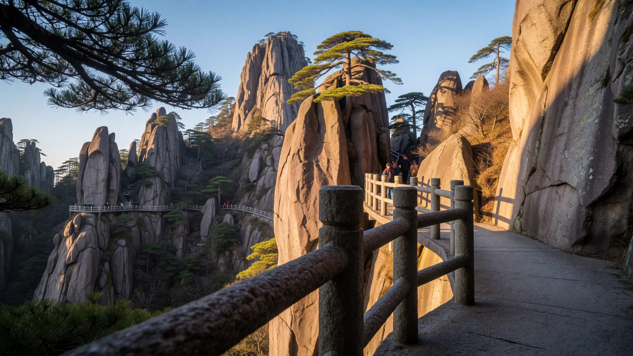
Mount Sanqing pairs Taoist meaning with sharp granite scenery, and it’s often calmer than some other famous rock mountains in China.
The place
Mount Sanqing (三清山, Sānqīng Shān) is a Taoist sacred mountain in Jiangxi Province, built around three main summits: Yujing, Yushui and Yuhua. The name points to the “Three Pure Ones”, the Taoist trinity, and the mountain’s layout really does feel like it was designed to tell that story as the ridges and viewpoints unfold.
Geographically, the place sits in the Huaiyu Mountains, and the rock character is unmistakable. Sanqingshan is a mass of granite, and the scenery is famous for strange rock formations and those twists of life—ancient trees and rhododendron-covered slopes. On a clear day the peaks look sculpted; in mist they turn into layered silhouettes, which changes the mood quickly as weather rolls in.
A lot of visitors come for the walking routes. There are broad, concrete trails on the mountain, in places clinging to steep faces, plus ropeways that take people much of the way up so the park can be enjoyed across different fitness levels. The trails connect lookout areas, rock clusters, and key cultural spots—especially around the old Taoist temple complex.
Sanqing is also a park in the full sense: it’s a refuge for plants and animals, and it’s been recognised as a National Geopark and then UNESCO-listed. That mix of sacred landscape, geology and ecology is the hook here—less about a single monument, more about spending a day (or two) moving between viewpoints and letting the mountain’s shapes do the talking.
Its story
For upwards of fifteen centuries, followers of Taoism have made pilgrimages to Mount Sanqing, yet the peak feels remarkably vibrant rather than stuck in the past. Its remoteness helped it avoid many of the disruptions that affected other parts of China, so the landscape stayed intact enough for worship and tourism to grow on top of older rhythms.
Over the last few decades, access changed the experience. Ropeways arrived in the 1990s and later improvements followed, which meant the route into the mountains became faster and more predictable for mainstream visitors. That’s partly why the mountain can feel less crowded than similarly dramatic rock landscapes: more people can reach the high viewpoints easily, yet the route still spreads through multiple areas rather than funnelling everyone into one single view.
Sanqing’s identity is strongly tied to its “three pure” symbolism. The three summit names—Yujing, Yushui and Yuhua—act like anchor points, and the mountain’s rock theatre reinforces that sense of a triad: pillars and cliffside formations appear in clusters, and the walking loops let visitors keep re-encountering the same geology from new angles.
The park’s long protection also shows in the details. Twisted pine and ancient rhododendrons bring seasonal textures, and the climate can shift rapidly compared with the base areas. In practice, that means the story of a visit changes hour by hour: sunshine highlights granite edges; cloud turns them soft; and occasional rain or cold snaps make the climb feel sharper and more alive.
What to see
- Yujing (玉京峰) summit area
Yujing (玉京峰) is the highest of Sanqing’s three main summits, and the surrounding viewpoints help stitch together the “three pure” idea across the ridge line. Expect wide sky views and granite angles that look different with every shift of cloud. - Rock formations around the Longevity Garden
The Longevity Garden area lets hikers move over and around large rocks, with a trail layout designed for lingering rather than sprinting. This is a good spot to pause and study how weathering shaped the granite into columns, slabs and curious ledges. - ‘Giant python emerging from the mountain’ pillar (巨蟒出山)
One famous stone pillar is described as resembling a giant python emerging from the mountain (巨蟒出山). It sits among the park’s clustered rock features, and it’s the kind of landmark people point to because it really reads like an animal shape once you find the right angle. - Sanqinggong (三清宫) Taoist temple complex
Sanqinggong (三清宫) is a Taoist temple complex near the northern end of the mountaintop, with a sequence of sights arranged around it. Carvings and gates line the path up from the entrance, adding cultural depth to the granite-and-tree scenery.
Culture
Mount Sanqing is a Taoist sacred mountain, and visiting feels different when the landscape is treated as a living “site of worship” rather than just a hiking destination. Sanqing’s three-summit symbolism isn’t just a name—it influences how routes are paced, where viewpoints sit, and how temple buildings fit into the walking network.
What helps visitors understand the place is that the mountain’s cultural side is built into the hike itself: temple areas sit within the larger loop system, and stone paths and gates create a sense of progression from general sightseeing to more focused, reverent spaces. Even the way people photograph can change around temple approaches.
Crowds do happen, especially around the most photographed rock and temple areas, but the mountain can still feel spacious because the trails spread through multiple viewpoints and rock clusters. In clear weather, people move for angles; in mist or after rain, the same areas become quieter and more thoughtful.
Visitor tip is simple: dress and behaviour should match the sacred context. Keep voices low near temple entrances, avoid blocking entrances when people are passing through, and be ready to remove or adjust footwear where the site asks it.
Be respectful near Sanqinggong: keep noise down, don’t block paths at gates, and follow any footwear rules you’re shown at temple entrances.
What to wear
Mount Sanqing is a mountain park, so clothing is about layers and grip first, not style. The terrain includes cliffside sections and long walking loops, and weather can feel colder than the base areas. A practical visitor outfit usually means breathable tops plus a warm layer, with a light waterproof if rain moves in.
Traditional culture is visible around Taoist spaces, where modest dress reads as the right tone. If planning to spend time near Sanqinggong (三清宫) and other temple approaches, wearing clothing that covers shoulders and keeps shorts/very short hems to a minimum helps everyone feel comfortable in the sacred setting. Avoid loud, overly revealing outfits around entrances and carved gate areas.
What people wear now is generally outdoor casual—comfortable walking shoes, long trousers or leggings, and a rain jacket when needed—because the main activity is hiking and admiring rock and trees. For footwear, choose shoes with good traction and wear socks you can hike in for hours; the stone can feel slippery when wet.
If visiting in the flowering period tied to rhododendrons (May), keep a head covering and lightweight long sleeves handy for sun and pollen. The best-looking photos happen after you’ve chosen comfort over fashion.
What to eat
- Snacks at small mountain huts — Near the ropeway and trail nodes inside the national park
Across Mount Sanqing, small huts sell simple snacks for hikers, often aimed at quick energy breaks between viewpoints. If travelling between ropeway sections, these huts are usually the easiest place to grab something without leaving the park. - Instant noodles on the mountain — Snack huts and eateries inside the park, away from the main hotels
Instant noodles show up as the most straightforward comfort food when you’re tired from climbing. They’re convenient for refuelling between rock clusters, especially when weather changes and people want something fast. - Fried chicken — Small snack huts along the mountain hiking areas
Fried chicken is one of the common quick bites sold at mountain huts. It’s the sort of item visitors buy when they want something savoury that’s easy to eat on the move before heading to the next viewpoint loop. - Restaurant meals at major hotels — Hotels near the top of the south and east ropeways
The major hotels on Mount Sanqing have their own restaurants, making them a more structured option for a sit-down meal. Expect these places to be the most consistent for groups who don’t want to rely on hut snacks. - Tea and light bites near hotel villages — At the base hotel villages near the south and east entrances
At the base of each entrance, hotel villages gather the basic visitor services. It’s a good area to look for light snacks and hot drinks after transfers before returning to the mountain trails.
Plan it
Best time. March–April for blossom, late October–November for cooler hiking; May brings rhododendron flowers, while June is rainy and can feel changeable on the slopes.
How long. 3–4
Getting there. Fly into a major airport in the region, then travel toward Shangrao or Jingdezhen. Depart from Yushan South (high-speed) station or Yushan Station, heading to the local bus terminal by vehicle, after which you can board standard services reaching the guest accommodations situated at the southern and eastern gates. From there, ropeways take you most of the way up; for northern trail access, use the relevant motorcycle-taxi connection described for the entrances.
Budget. mid
Tips
- Start early to catch clearer light at key rock areas and reduce time in peak visitor flow
- Use ropeways if the goal is viewpoints; add walking loops where trails let you explore formations
- Plan for rapid weather changes and colder temperatures than the base
- Carry some cash for smaller purchases at mountain huts and at entrance areas
- Bring layers even in warmer months; mist and wind can make the top feel much cooler
Etiquette
- Stay on marked trails, especially on steep or cliffside sections
- Follow any footwear or access rules near Taoist temple entrances and carvings
- Keep voices down around temple areas so the setting stays calm for worshippers
Nearby
Sources
- Wikidata Q873358 (CC0)
- Wikipedia (rev 1362860744) (CC BY-SA 4.0)
- Wikivoyage (rev 4692692) (CC BY-SA 4.0)
- Photo photos/01-19190-sanqingshan-45434925915.jpg (CC BY 2.5)
- Photo photos/02-19194-sanqingshan-46786622272.jpg (CC BY 2.5)
- Photo photos/03-sanqingshan3.jpg (Public domain)
- Photo photos/04-19265-sanqingshan-46297083182.jpg (CC BY 2.5)
- Photo photos/05-19267-sanqingshan-45624205064.jpg (CC BY 2.5)
- Photo photos/06-19250-sanqingshan-39873732113.jpg (CC BY 2.5)
- Photo photos/07-19185-sanqingshan-45434920615.jpg (CC BY 2.5)
- Photo photos/08-19240-sanqingshan-45624196794.jpg (CC BY 2.5)


