Lachish
Lachish, Israel
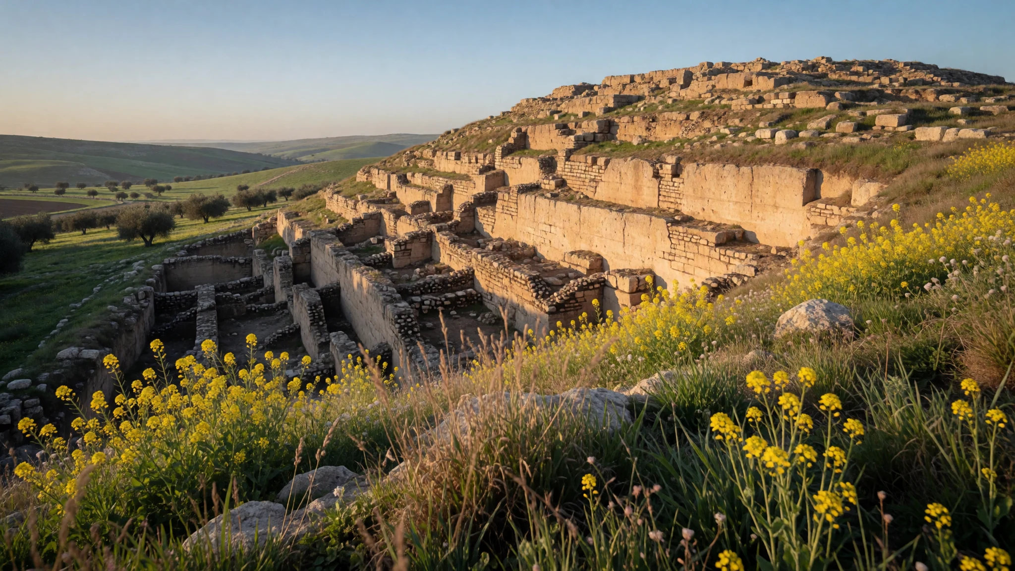
Lachish offers an extraordinary journey into the ruined layers of a powerful Canaanite and Israelite royal city preserved in the southern lowlands.
The place
Lachish sits as an imposing ancient tell, known locally as Tell el-Duweir, rising above the Shephelah lowlands on the southern bank of the Lakhish River in Israel. Today, this former settlement is operated as a protected national park by the national park authority, standing near the modern moshav of Lakhish which took its name from the ancient ruins. The site commands a strategic landscape of rolling hills and agricultural fields that once guarded major commercial and military routes connecting the coastal plain to the hill country of Judah. Walking across the mound reveals deep trenches, massive mudbrick foundations, and stark stone remnants that speak of a turbulent past marked by successive empires. Visitors wander through a landscape of quiet earth and exposed masonry, where the dry desert breeze carries the echoes of ancient trade, royal correspondence, and devastating military sieges. The surrounding terrain remains largely rural, dominated by orchards and open country paths that invite quiet exploration away from the crowded urban centres of the coastal strip. Springtime brings a brief flush of green and wildflowers across the terraces before the summer heat settles over the dry lowlands, making the archaeological remains stand out sharply against the pale, sun-bleached soil. Every corner of the tell exposes fragments of ancient pottery embedded in the footpaths, reminding every traveller of the deep layers of human habitation buried beneath their boots as they contemplate the immense historical weight of this ancient border fortress.
Its story
The history of Lachish stretches back across millennia of shifting civilisations, beginning during the Pottery Neolithic period when early flint tool makers first camped on the mound. Occupation continued through the Chalcolithic period as part of the Ghassulian culture, followed by major urban development in the Early Bronze Age when Khirbet Kerak pottery was traded across the region. A severe regional drought brought an end to this early prosperity, leaving the settlement largely abandoned until it was resettled at the dawn of the Middle Bronze Age. During this later era, the mound grew into a fortified stronghold featuring massive mudbrick fortresses and palaces that housed local rulers who corresponded with foreign powers. By the mid-fourteen century BCE, Lachish appears in historical records as a prominent Canaanite city-state communicating with the Egyptian court through cuneiform clay tablets found at Amarna. Violent destructions marked the end of the Late Bronze Age, attributed variously to internal conflicts, regional upheavals, or invading groups. According to later biblical accounts written centuries afterward, the city was subsequently conquered during campaigns in the land of Canaan. Subsequent centuries saw Lachish rebuilt as a major administrative centre of the Kingdom of Judah, fortified with thick walls and grand gates designed to withstand the might of expanding imperial armies from the ancient Near East before its eventual destruction.
What to see
- The Main Gate — Lower approach of the tell
The Main Gate at Lachish is a complex multi-chambered entryway that once controlled all civilian and military traffic entering the fortified city. Visitors can examine the massive stone foundations, guardrooms, and outer courtyards where ancient officials sat to conduct commerce, hear legal disputes, and manage the daily administrative affairs of the royal settlement. - The Commander's House — Central summit of the mound
The Commander's House sits atop the mound, revealing the ruined layout of a high-ranking administrative building from the Judean period. Walking among the surviving stone walls offers a clear perspective on the domestic and governing arrangements of officials who managed this critical border outpost during times of regional conflict. - The Siege Ramp — Western slope of the tell
The Siege Ramp stands as a massive wedge of earth and stones piled against the western wall by ancient attackers attempting to breach the fortifications. This monumental engineering feat remains one of the best-preserved military siege works from the ancient world, allowing travellers to walk the incline and visualise the desperate battles fought across these ramparts. - Cuneiform Archive Site — Palace precinct area
The Cuneiform Archive Site marks the discovery zone where ancient clay tablets inscribed in Akkadian script were unearthed, revealing correspondence between local Canaanite rulers and Egyptian pharaohs. Although the original tablets now reside in major museums abroad, visiting the exact discovery spot connects travellers directly to the diplomatic networks of the ancient Bronze Age. - The Tell Panorama — Summit peak
The Tell Panorama provides a sweeping vantage point across the Shephelah lowlands, agricultural fields, and nearby modern settlements from the highest point of Lachish. This lookout point helps visitors understand the vital geographic position the ancient city held along major trade routes linking the coastal plains with the interior hills of Judea.
Culture
Culture in Lachish and the surrounding region reflects a vibrant, direct society where people communicate with complete openness and minimal formality. Locals are typically warm, highly inquisitive about visitors from abroad, and more than willing to offer assistance, advice, or directions when needed. This straightforward communicative style, often called dugriut, can occasionally strike uninitiated travellers as blunt or confrontational, but it carries no underlying hostility and simply reflects an authentic local ethos of honesty and directness. Society operates with a modern, Western-oriented outlook while remaining deeply connected to historical roots, seasonal agriculture, and ancient traditions. Visitors will find that everyday interactions proceed smoothly when met with reciprocal warmth and an appreciation for straightforward dialogue. When visiting archaeological sites or rural communities near Lachish, always dress respectfully and follow marked pathways to protect fragile historical structures.
What to wear
Fashion in Lachish and modern Israel is casual, practical, and heavily influenced by the warm Mediterranean climate. Everyday wear for locals consists largely of breathable cotton t-shirts, jeans, shorts, and comfortable walking shoes or sandals suitable for an active outdoor lifestyle. Traditional garments are rarely seen in daily life outside of specific religious communities or cultural celebrations, where modest attire involving long skirts, head coverings, and tailored jackets remains customary. For travellers exploring the archaeological ruins of Lachish, practical considerations are essential due to the uneven terrain, exposed dusty paths, and intense sunshine. Visitors should wear sturdy trainers or walking boots, a wide-brimmed hat, sunglasses, and lightweight layers that provide adequate sun protection while allowing freedom of movement. When transitioning from outdoor exploration to traditional neighbourhoods or religious sites across the country, both men and women should carry clothing that covers their shoulders and knees to show proper respect for local modesty standards.
What to eat
- Hummus and Falafel — Any traditional neighbourhood eatery or local market
Creamy chickpea paste blended with tahini, olive oil, and lemon juice, served alongside freshly fried herb falafel balls and warm pita bread. This staple dish can be found in casual roadside eateries and traditional neighbourhood markets throughout the country. - Shakshuka — Morning cafes and traditional breakfast spots
Poached eggs simmered in a spiced, vibrant sauce of ripe tomatoes, chilli peppers, onions, and garlic, often served directly from a hot iron skillet with crusty bread. It is widely enjoyed as a hearty morning meal at local cafes. - Sabich — Street food stalls and neighbourhood snack bars
A popular pita sandwich stuffed with fried aubergine, hard-boiled eggs, tahini, salad, and pickles, seasoned with amba mango sauce. Street food stalls across urban neighbourhoods serve this flavorful specialty throughout the day. - Jerusalem Mixed Grill — Traditional grill houses and bustling market stalls
A spiced dish of mixed chicken meats including hearts, liver, and spleen, seared on a flat-top grill with onions and Middle Eastern spices, then stuffed into a fresh pita. Look for specialized grill houses in bustling city markets. - Bourekas — Local neighbourhood bakeries and street-corner kiosks
Flaky, baked pastry turnovers filled with salty white cheese, spinach, or mashed potato, often topped with sesame seeds. Bakeries across every town offer these warm, savory treats from early morning until late afternoon.
Plan it
Best time. March to April for pleasant spring weather and wildflowers, or October to November for mild autumn temperatures; June through August brings intense heat and dry conditions.
How long. 1–2
Getting there. Fly into Ben Gurion Airport near Tel Aviv, then rent a car or take regional rail and bus connections toward the southern Shephelah lowlands.
Budget. mid
Tips
- Check the official nature and parks authority website for opening hours before visiting the site
- Arrive early in the morning during warmer months to avoid afternoon heat on the exposed mound
- Carry ample drinking water as there are limited facilities directly on the archaeological tell
- Wear sturdy walking shoes to navigate the uneven stone paths and steep earth ramps safely
- Obtain your electronic travel authorization online prior to departure for smooth entry into the country
Etiquette
- Expect direct and straightforward communication from locals without taking offense
- Dress modestly with covered shoulders and knees when visiting religious or conservative areas
- Tip waitstaff in sit-down restaurants to acknowledge service while checking bills for added fees
Nearby
Sources
- Wikidata Q848509 (CC0)
- Wikipedia (rev 1374672351) (CC-BY-SA 4.0)
- Wikivoyage (rev 5405511) (CC-BY-SA 4.0)