Vancouver Island
Vancouver Island, Canada
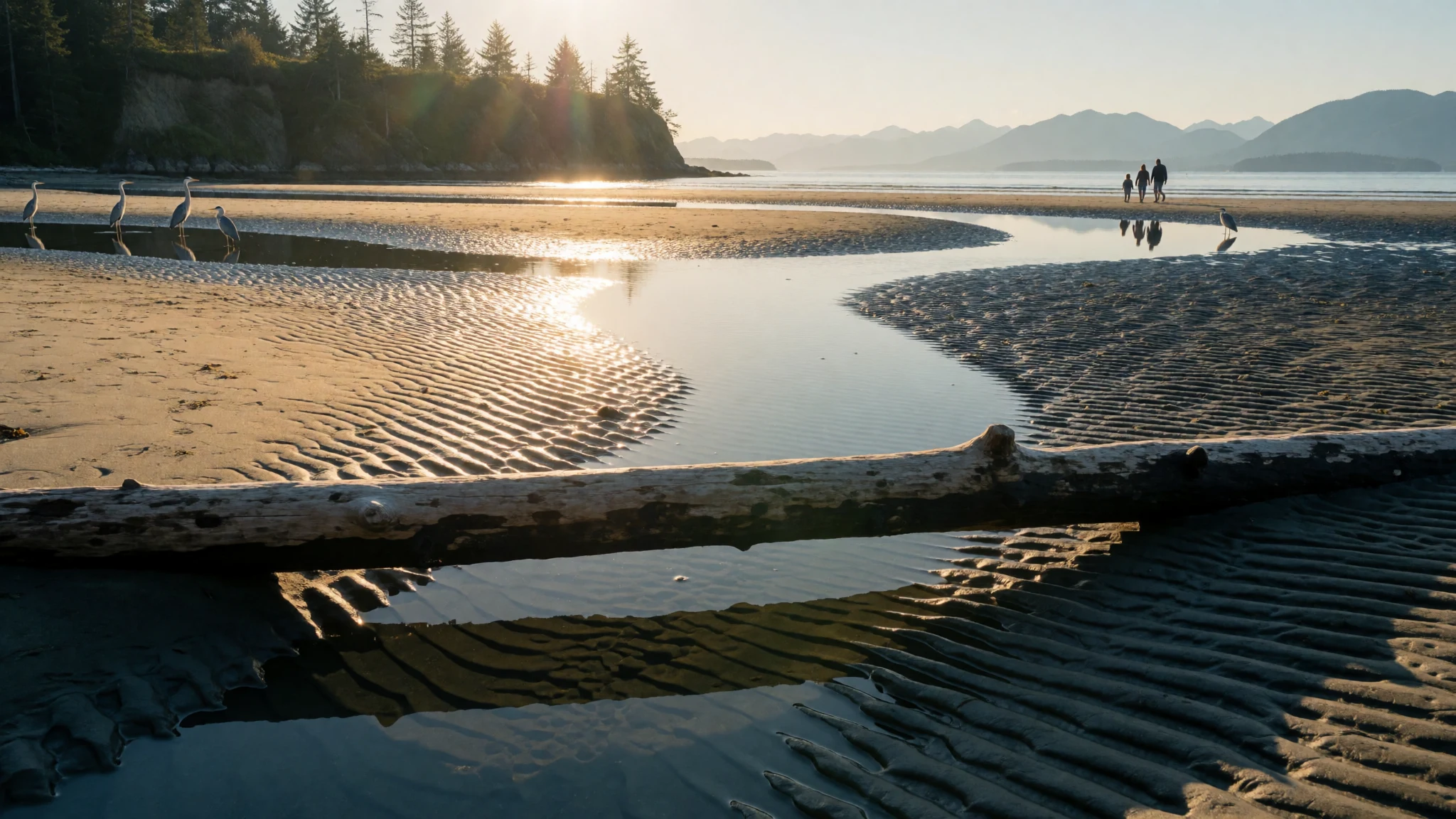
Vancouver Island packs old-growth forest, tidal beaches, orca waters and a mild southern coast into one ferry ride from the mainland.
The place
Vancouver Island sits off the Pacific coast of mainland Canada, part of British Columbia, and it holds several different landscapes at once. About 864,864 people live here. Close to half of them are around Victoria and its neighbouring municipalities at the southern tip, and the rest are spread among east-coast towns such as Nanaimo, Campbell River, Courtenay, Port Alberni and Parksville. The island stretches for hundreds of kilometres from a sunny south to a wilder, thinly settled north. Its outer coast faces open ocean, while the inner coast looks across a sheltered strait to the mainland. No road or rail bridge links it to the mainland, so every visitor arrives by ferry or by air, and that shapes the rhythm of a trip. The south-east is unusually mild for Canada, and olives and lemons now grow in a few spots there. Further north and on the west side the weather turns wetter and the forest closes in: tall conifers, moss on every branch, mist lingering in the valleys. Beaches range from broad tidal flats on the east side, where the sea retreats a long way at low tide, to storm-battered stretches in the west that people visit in winter just to watch the surf. Mountains run down the spine, with alpine meadows and lakes above the tree line. Wildlife is part of the draw: orcas in the northern straits, bears on guided tours, seabirds along the shore. Towns are small and practical, and distances take longer than a map suggests.
Its story
Vancouver Island has been home to Indigenous peoples for thousands of years, long before European ships appeared offshore. Three broad language groupings are usually named: the Kwakwaka'wakw in the north and north-west, the Nuu-chah-nulth along most of the west coast, and the Coast Salish peoples in the south-east and along the Strait of Juan de Fuca. Their cultures grew out of the sea, rivers and forests around them. The Kwakwaka'wakw, long called Kwakiutl by outsiders, speak Kwak'wala, a language now used by only a small number of people. Their potlatch, a ceremonial gathering of feasting, gift-giving and witnessing, was banned by the Canadian government in 1885 and has been revived in recent decades. Spanish and British naval expeditions reached the coast in the late eighteenth century. In 1792 at Nootka Sound, the Spanish commander Juan Francisco de la Bodega y Quadra and the British captain George Vancouver talked through a dispute known as the Nootka Crisis, and did so on friendly terms. The island first carried both men's names, though the Spaniard's soon fell away. A separate colony of the island was later created, with its own seal, before it merged into British Columbia. The history here therefore has two layers: a long Indigenous presence that continues in living communities such as Alert Bay and Fort Rupert, and a shorter colonial chapter whose names still sit on the map.
What to see
- Cathedral Grove — Arrowsmith and Coombs area, central island
Cathedral Grove, in the Arrowsmith and Coombs area of central Vancouver Island, is a stand of giant old-growth forest beside the main highway. Walkways loop beneath huge trunks and thick moss. It is easy to reach, so it gets busy in summer; early mornings are quieter, and the light under the canopy is softer.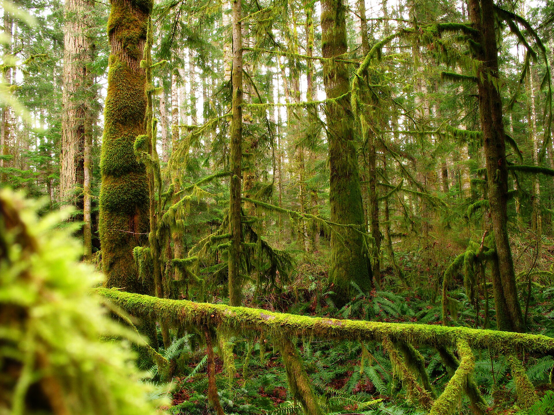
- Rathtrevor and Parksville beaches — Parksville, east coast
On the east coast near Parksville, the tide goes out for more than a kilometre, leaving flat sand, shallow pools and a wide horizon. Families wade and dig at low tide, while herons and gulls work the margins. Check tide tables before visiting, because at high water the beach shrinks dramatically. - Coombs market — Coombs, central island
Coombs is a small roadside village known for a market whose roof carries grazing goats. It is a cheerful, slightly kitsch stop between the ferry port at Nanaimo and the west coast, good for a snack, local produce and a stretch of the legs before the winding road onward. - Telegraph Cove and Johnstone Strait — North island
Telegraph Cove, at the north end of the island, is the usual starting point for kayak trips and boat tours into Johnstone Strait, where orcas feed in summer. Several operators run guided paddles and whale-watching outings. Book ahead for peak months, and expect cool, damp conditions on the water even on bright days. - East Sooke Regional Park — Sooke, south island
East Sooke Regional Park, a short drive west of Victoria, offers rocky coastal trails, tide pools and viewpoints such as Mount Maguire, from which the mountains of Washington state can be seen across the water. Paths are uneven and can be slippery, so sturdy footwear matters more than distance.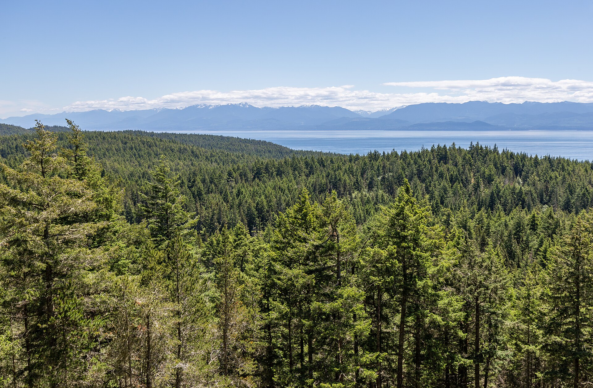
Culture
Vancouver Island's culture rests on two things: Indigenous traditions that are still practised, and a settler heritage built around ports, forestry and fishing. The Kwakwaka'wakw, Nuu-chah-nulth and Coast Salish nations each have their own languages, art styles and ceremonies. Carved cedar poles, painted house fronts, woven goods and masks are not decoration; they carry family histories, rights and responsibilities. The potlatch, once banned by the Canadian government, is again practised openly, and communities such as Alert Bay and Fort Rupert are places where that revival is visible. Many towns now open with an acknowledgement of whose land they stand on, and Indigenous-led tours, galleries and cultural centres are a respectful way for visitors to learn directly from the people concerned. Settler culture is easygoing and outdoorsy. Conversations turn quickly to weather, ferries, tides and trails, and plans change when sailings fill or fog rolls in. Small towns have craft markets, farm stalls and local breweries, and people tend to be friendly but unhurried. Victoria leans towards gardens and tea-room Britishness, while the west coast leans towards surf, rain gear and a slower pace. Visitors should ask permission before photographing Indigenous people, ceremonies or private houses, and should treat carved poles and cultural sites as living property rather than backdrops.
What to wear
On Vancouver Island, traditional dress belongs mainly to Indigenous nations whose textiles come from the local forest and sea. Coast Salish weavers are known for blankets worked from wool, and in the north the Kwakwaka'wakw have long used cedar bark for clothing and regalia. Button blankets, painted or carved masks, and headdresses appear at potlatches and other ceremonies rather than in daily life, and photographs of them should be treated with respect. Everyday clothing now is practical and weather-led. Locals wear fleece, waterproof shells, wool socks, hiking boots and rubber boots, often in muted colours, and layers matter more than style. Victoria is a little smarter, with cafés and theatres where neat casual clothes are normal, but nobody dresses formally for dinner outside a few special occasions. Visitors should dress for changeable weather. A rain jacket is worth packing in any season, since the west side especially can be wet even in summer. Bring warm layers for boat trips, because the water keeps the air cool, and wear sturdy shoes with grip for tide pools, wet roots and rocky trails. Sandals and a sun hat suit the dry south-east in July and August. There are no strict modesty rules, though covering up a little is sensible when visiting a community cultural centre or a ceremony.
What to eat
- Smoked or grilled salmon — harbourside fish counters, markets and Indigenous-run eateries
Salmon is central to west coast cooking and to Indigenous food traditions. It appears smoked, candied, cedar-planked or grilled over open fires. Look for it at harbourside fish counters, at farmers' markets and in Indigenous-run eateries and cafés. - Nanaimo bar — bakeries and cafés in Nanaimo and other towns
This no-bake square has a crumbly chocolate-coconut base, a pale custard-flavoured middle and a layer of hard chocolate on top. It is very sweet and best shared with coffee. Bakeries and cafés in Nanaimo and across the island sell their own versions. - Fresh oysters and shellfish — harbour seafood shacks and east-coast oyster farms
Cold, clean inshore water supports oyster farms, and clams, mussels, prawns and crab turn up on menus along the coast. Eating them close to where they were landed is the point. Try seafood shacks near harbours or stalls on the east coast. - Bannock — cultural centres, festivals and Indigenous food stalls
Bannock is a simple, golden fried or baked bread made by many Indigenous communities across Canada. It is served plain, with jam, or as a base for savoury toppings. Look for it at powwows, festivals, cultural centres and Indigenous food stalls. - Island farm produce and cheese — farm stands and weekend farmers' markets in the Cowichan and Saanich areas
The mild south-east supports orchards, berry farms, dairies and small vineyards. Cheese, jams, cider and seasonal fruit are sold at farm gates and roadside stands. Stopping at a rural stall is a pleasant way to taste what grows here.
Plan it
Best time. June to September is the most reliable window, with drier, warmer weather in the south-east and the best conditions for kayaking, whale watching and hiking. Winter is wet and mild on the coast, which suits storm watching and surfing, but the west side can be stormy and some services slow down.
How long. 4–6
Getting there. No road or rail link crosses the strait, so travellers come by BC Ferries from Tsawwassen or Horseshoe Bay near Vancouver, to Swartz Bay near Victoria or to Nanaimo, with crossings of roughly two hours or a little less. There are also smaller routes such as Powell River to Comox, and flights into Victoria and other island airports. A car makes the rest of the island far easier.
Budget. mid
Tips
- Book ferry reservations early for summer weekends and holidays, since sailings can fill and leave walk-up cars waiting
- Check tide tables before visiting east-coast beaches and tide pools
- Start at Cathedral Grove and other popular forests early in the morning to avoid the crowds
- Pack a waterproof jacket in every season, and warm layers for boat trips
- Fuel up and eat before long drives to the north or west, as towns are small and far apart
Etiquette
- Ask before photographing Indigenous people, ceremonies or carved poles
- Keep a safe distance from wildlife and follow your tour operator's guidance on bears and whales
- Stay on marked trails in old-growth forest and take rubbish with you
Nearby
Sources
- Wikidata Q170479 (CC0)
- Wikipedia: Vancouver Island (CC BY-SA 4.0)
- Wikivoyage: Vancouver Island (CC BY-SA 4.0)
- NASA, Vancouver Island satellite image (Public domain)
- User:Nikater, Vancouver Island map (Public domain)
- Edward S. Curtis, Kwakiutl bridal group, 1914 (Public domain)
- Portrait of Dionisio Alcalá Galiano (Public domain)
- Will.Jackson.Vancouver, Great Seal of the Colony of the Island of Vancouver (CC BY-SA 4.0)
- Keefer4, The Golden Hinde (CC BY-SA 2.5)
- TheOtherJohnC, Mossy trees, Vancouver Island (CC BY 2.5)
- Michal Klajban, View from Mount Maguire, East Sooke Regional Park (CC BY-SA 4.0)


