Choquequirao
Choquequirao, Peru
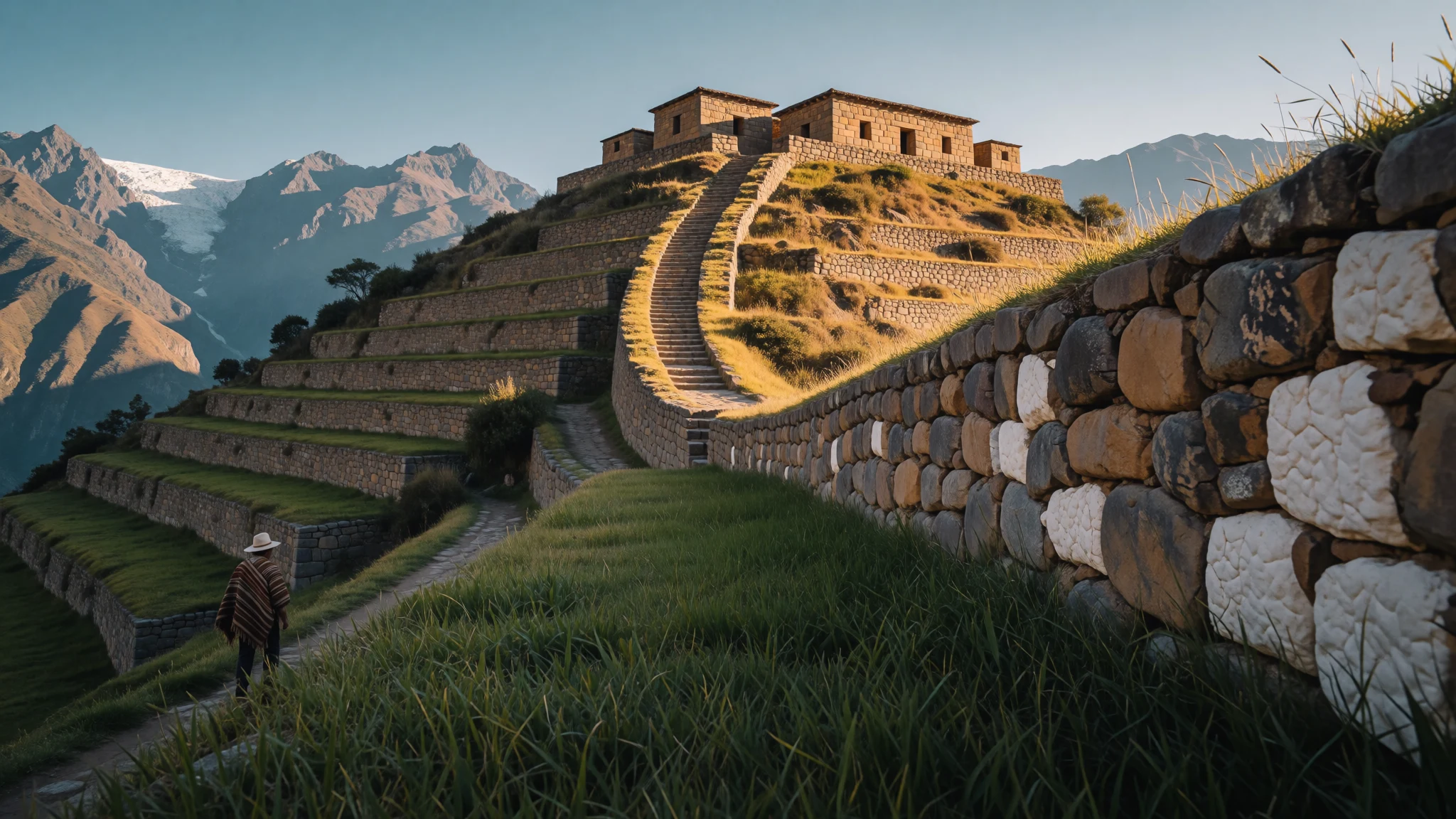
Choquequirao is an Inca citadel on a remote Andean ridge, reached only on foot, where terraces and white-stone llamas are shared with few visitors.
The place
Choquequirao is an Inca site in the Cusco Region of southern Peru, set on a steep spur high above the Apurímac River canyon. No road reaches it. Getting there means a hike of two days from the trailhead villages, with a long descent into the canyon and a hard climb out the far side, so the place stays far quieter than its famous cousin Machu Picchu. The ruins sit at about 3,050 metres, while the river far below runs at about 1,450 metres. That drop shapes everything: the heat in the canyon, the cool of the ridge, the cloud that drifts up in the afternoon. The setting is the Vilcabamba range, with forested slopes and glaciated peaks behind. The built area is organised around a truncated hilltop called Sunch'u Pata. Temples, elite houses and bath-and-fountain systems are strung along the ridge crest around two plazas, and terraces fall away in long steps on every side. On some of them, white stones are set into the walls in the shape of llamas. Only part of the site has been cleared and excavated, and forest still covers much of the rest. Most walkers camp nearby for a night or two, buying water and basics from small trailside stalls. Visitors expecting a manicured archaeological park will find instead a working site with rough paths, steep stairs and very long views.
Its story
Choquequirao belongs to the Inca Empire, which its own people called Tahuantinsuyo, and the buildings appear to come from two phases of growth. A common explanation is that the emperor Pachacuti first laid the place out, and that his son Tupac Inca Yupanqui later reworked and enlarged it after taking the throne. The site lies inside country thought to have been Pachacuti's personal estate, a web of river valleys that also holds Machu Picchu, Choquesuysuy and other sites with kindred architecture. Some features echo a style linked with the Chachapoya people of the northern Andes, which hints that Chachapoya labourers helped build it. Colonial paperwork points the same way: Tupa Sayri, a descendant of Tupac Inca, laid claim to the site and its neighbouring lands under Spanish rule. Its position suggests a working role as well as a retreat. Peru's tourism authorities read it as probably a gatehouse on the approach to the Vilcabamba region and a hub for administration. After Manco Inca Yupanqui lost his siege of Cusco in 1535, he withdrew into this rugged country, and Choquequirao became one of the refuges of Inca resistance to the Spanish. That mix of estate, checkpoint and last stand explains why the site is laid out as a small city and not merely a lookout, and why archaeologists still have so much left to uncover.
What to see
- Hauccaypata, the main plaza — Centre of the ruins
The open heart of Choquequirao, lined with large buildings that served ceremonial purposes. Standing here gives a sense of how the ridge was levelled and shaped for gatherings, with terraces dropping away on both sides and mountains closing the horizon. It is the natural first stop before exploring the sectors around it.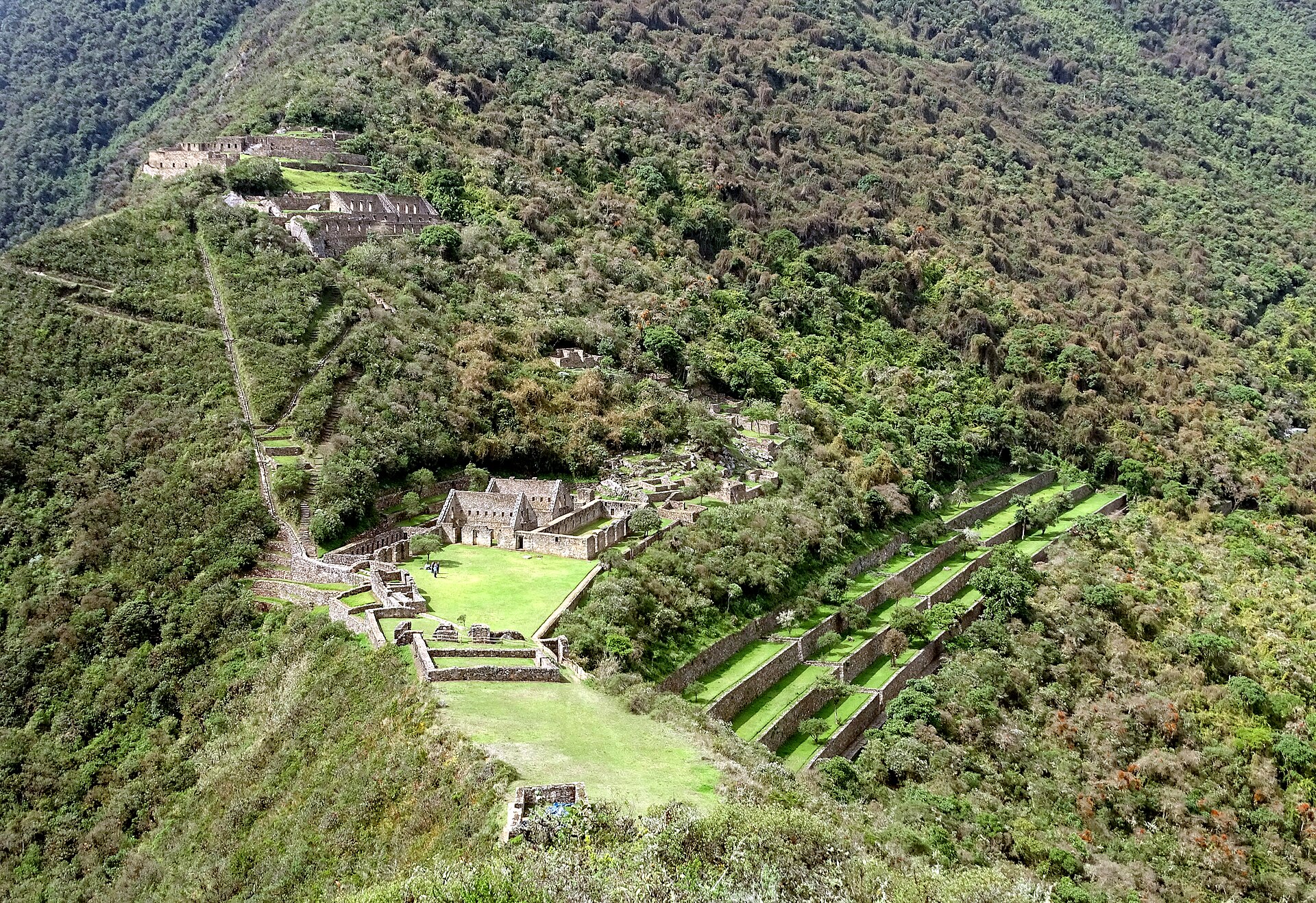
- Ushno ceremonial platform — South of the main plaza
A semicircular field on a rise south of the main plaza, with wide views over the canyon and surrounding peaks. It may have been used for religious ceremonies and for watching the sky. Come here late in the day if the cloud allows, when the light turns the slopes gold. - Las Llamas terraces — Lower slopes of the site
A run of agricultural terraces joined by steep stairs and irrigation channels. Set into the walls are the white stone llamas that make Choquequirao distinctive, each pale figure standing out against darker masonry. Finding them takes patience and a careful eye, and the stairs are steep, so allow time and good footing.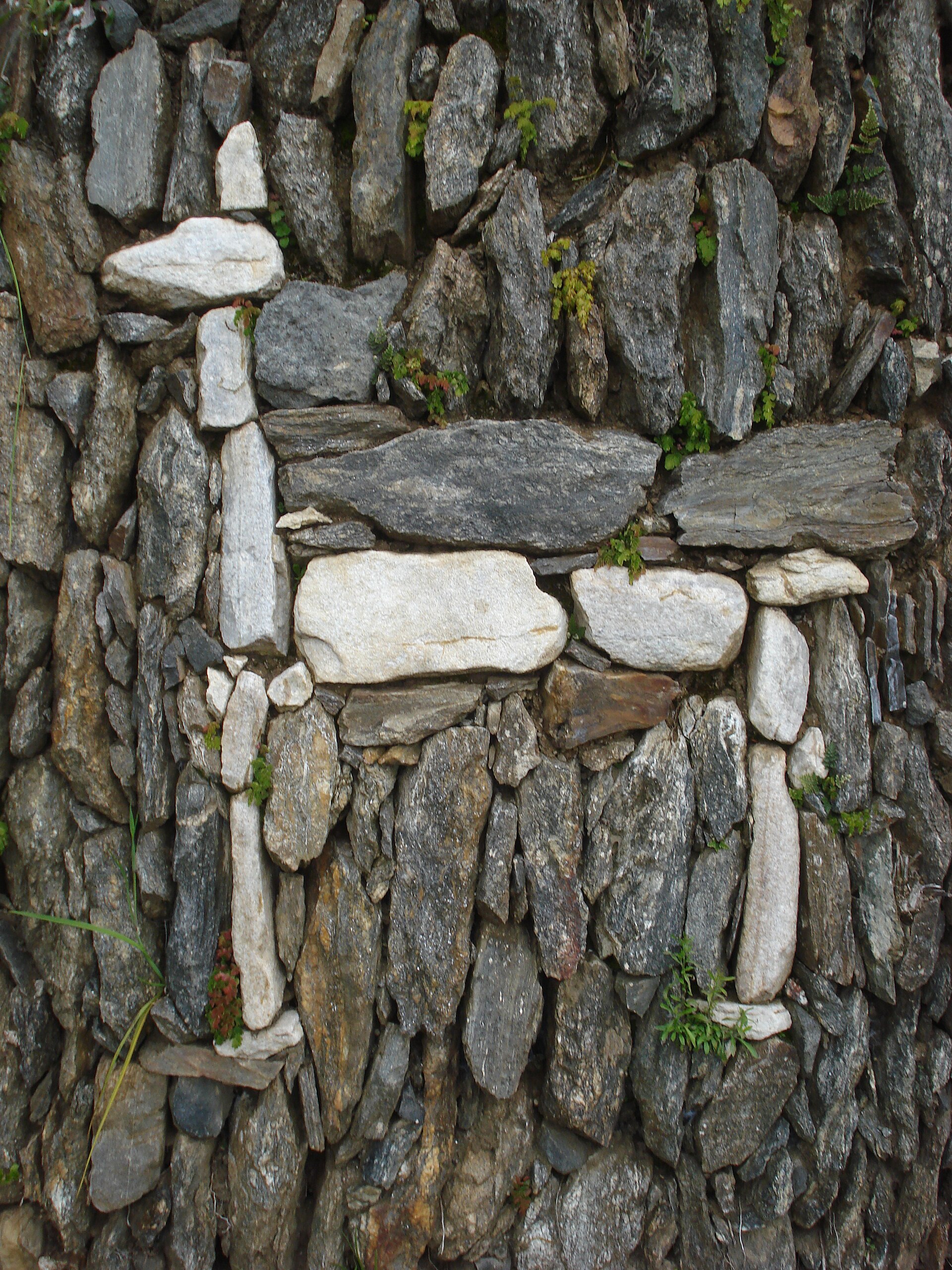
- Ceremonial cultivation terraces — Below the main plaza
Below the main square lie wide terraces, with a long stone path running their full length. They show how farming and ritual were mixed together here. Walking the path gives the best feel for the scale of the earthworks, and for how much labour went into holding a steep mountainside in place.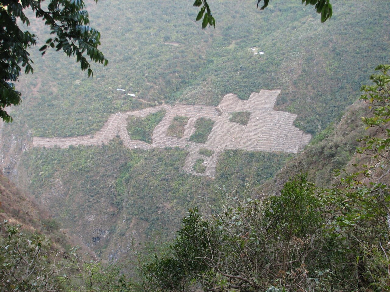
- Upper plaza and water channels — Hill above the main plaza
On a hill above the main plaza stand warehouses, priests' residences, fountains and stone water channels. This is a good place to see how the Inca moved mountain water through a settlement. Look for the small cascades and the neat doorways of the stone houses, which carry the same careful finish as the larger buildings.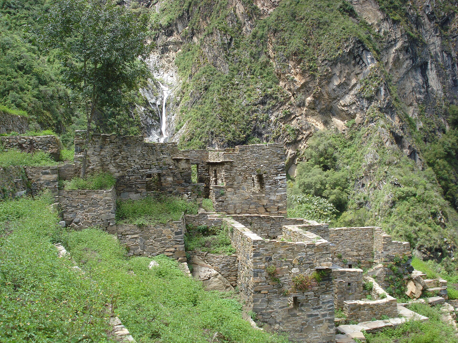
- Temple of Illapa and priests' houses — Southern edge of the cleared area
At the southern end of the cleared area, a temple used by priests sits among ceremonial terraces. Illapa was the Inca power of thunder and weather, a fitting patron for a ridge where storms build fast. It is a quieter corner, usually reached after the main sectors, and rewards the extra walk.
Culture
Choquequirao sits in Quechua-speaking country, and the people living along its approaches, in villages such as Cachora, come from communities that farmed these slopes long before trekkers arrived. Many work as arrieros, the muleteers who carry loads up and down the canyon, and their knowledge of the trail is a living skill, not a performance. The Inca tied the sacred to the landscape: mountains, springs and rock outcrops were treated as living presences, and the Ushno platform, the temples and the fountain systems on the ridge show how water and sky were woven into ceremony. In many Andean households that outlook has not vanished. Offerings of coca leaves, chicha poured on the ground and thanks given to the earth and the mountains remain familiar gestures, often blended with the Catholic practice introduced after the Spanish conquest. Coca leaf is also brewed as tea and chewed by many walkers and porters to ease the altitude, and it is an ordinary part of daily life here. The site carries the weight of the resistance story too, since it sheltered those who refused to submit to Spanish rule. Greetings matter: a friendly word before any request goes a long way, and a little Spanish helps far more than English. Stay on the marked paths, never climb or sit on the ancient walls and terraces, and ask before photographing the muleteers and villagers you meet.
What to wear
The traditional dress around Choquequirao is that of the Cusco highlands, made from sheep and alpaca wool, spun by hand and woven in strong colours. Women wear layered skirts called polleras, a woven shoulder cloth known as a lliclla and a decorated hat; men are associated with ponchos and the knitted chullo cap with ear flaps. Full costume is mostly worn for festivals and in market towns now. In the villages on the way to the ruins, everyday clothing is practical: jeans or work trousers, fleeces, sun hats or baseball caps, and rubber boots or trainers for the fields. Visitors should dress for a hike, not a ruin. Sturdy, broken-in boots with good grip matter most, for the long stony descent and the climb out. Long, light trousers protect against sun, scrub and biting insects, and a hat, sunscreen and sunglasses are essential. Pack layers: the canyon floor is hot by day, while the ridge and camps cool quickly after dark, and the rainy months call for a proper waterproof. There is no formal dress code at the ruins, but covering shoulders and avoiding very short shorts is polite in the villages.
What to eat
- Trailside soup — Small eateries at trail settlements such as Chiquisca, Santa Rosa and Marampata
A bowl of simple, filling soup is the standard meal for walkers on this route. It is plain, hot and welcome after a long day on the trail, and often the only cooked option before the ruins. - Rice with egg — Trailside stalls and campsite shops along the walk
A heaped plate of rice with eggs, sometimes with a few vegetables, is cooked in basic kitchens along the route. It is not elaborate, but it gives the carbohydrates needed for the climbs and is easy to find. - Chicha — Village shops and rest stops on the approach
Chicha is the traditional Andean drink, usually made from fermented maize, and it is sold widely along the trail. Flavour varies from sweet to sour, and strength varies too, so a small glass is a sensible start. - Mate de coca — Camps, village homes and small eateries
Tea made from coca leaves is the usual local answer to altitude, served hot and mildly bitter. Walkers often drink it at breakfast or camp, and it is as ordinary here as a cup of chai or builder's tea elsewhere. - Fresh fruit and snacks — Small shops at campsites along the route
Stalls at the campsites sell fruit, biscuits, boiled eggs and soft drinks, which makes useful trail food. Supplies are limited and carried in by mule, so it is best to buy sensibly and bring some of your own.
Plan it
Best time. May to September is the usual window, when the dry season brings clearer skies and firmer trails, though nights on the ridge are cold. The wetter months make the paths slippery and views less reliable, and the canyon floor can be hot at any time of year.
How long. 4–5
Getting there. Fly to Cusco, then take a bus from the main bus terminal towards Abancay and get off at the Ramal junction, the turn-off for Cachora and Huanipaca. From there a taxi or a walk downhill reaches the village of Cachora, the most common trailhead. Other routes start at Huanipaca and Yanama.
Budget. low
Tips
- Spend a couple of days in Cusco first to adjust to the altitude before the long climbs
- Check bus times at the terminal, since timetables are rarely online
- Hire an arriero and mules in Cachora if you want to carry less; ask at the shops on the main square
- Carry cash in small notes for stalls and campsites, as card payment is not an option on the trail
- Treat or filter stream water, and carry enough for the dry stretches
Etiquette
- Greet people on the trail and in the villages before asking for anything
- Take all rubbish out with you, including at campsites
- Do not climb on walls or terraces, and keep to the paths
Nearby
Sources
- Wikidata Q1076285 (CC0)
- Wikipedia: Choquequirao (rev 1372801896) (CC BY-SA 4.0)
- Wikivoyage: Choquequirao (rev 5238465) (CC BY-SA 4.0)
- Photo: The ruins of Choquequirao, Bryan Dougherty (CC BY-SA 2.0)
- Photo: Choquequirao main structures, Sucram Yef (CC BY 2.5)
- Photo: Truncated hilltop at Choquequirao, Ericbronder (CC BY 3.0)
- Photo: Terrazas de Choquequirao, Ericbronder (CC BY 3.0)
- Photo: White stone woman, Harley Calvert (CC BY 3.0)
- Photo: White stone llama, Harleyca (CC BY 3.0)
- Photo: Trail from Cachora, Danielle Pereira (CC BY 2.5)
- Photo: Inca Stone House Cascade, Harley Calvert (CC BY 3.0)


