Chihuahua
Chihuahua, Mexico
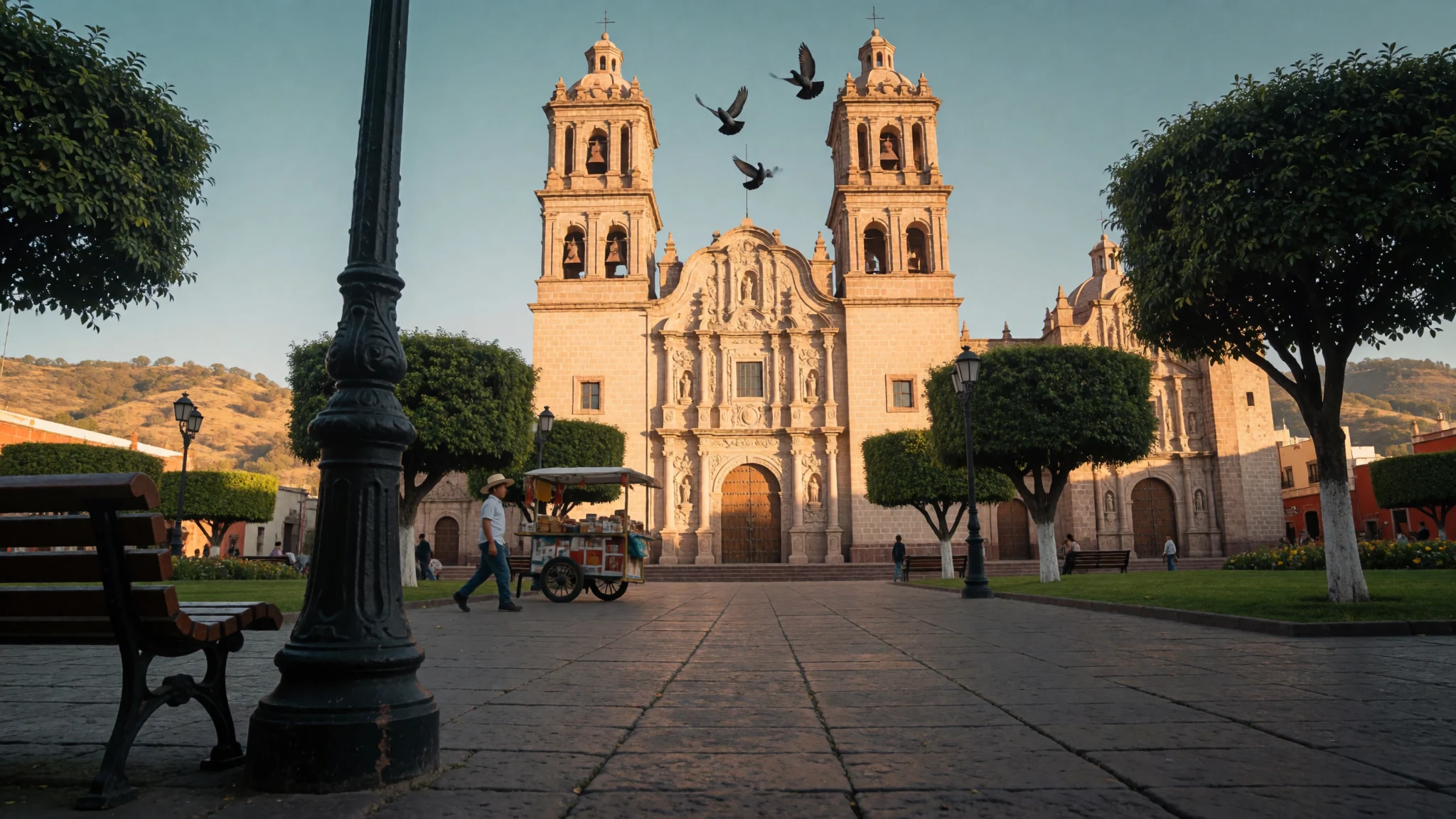
Chihuahua is a high-desert northern Mexican capital where colonial churches, revolution-era history and a relaxed cattle-country food scene sit within a short walk.
The place
Chihuahua is the capital of the Mexican state that shares its name, and it sits on a dry plateau at 1,415 metres, on the western side of the Chihuahuan Desert. The height matters. It keeps the city cooler than the low desert to the east, gives long clear days and dry air, and lets winter nights fall to frost. About 926,000 people live in the city itself, and the wider metropolitan area is close to a million.
On the map the city is roughly an L. Plains open to the north, hills close in on both flanks and to the south, and the Chuviscar River, usually a modest stream, runs east to west through the middle. Teófilo Borunda Avenue follows that line, while a fast ring road, the Periférico de la Juventud, carries traffic north and south across the western side.
The historic centre is compact and easy on foot. The cathedral and the Plaza de Armas anchor it, and several museums occupy old mansions and former government buildings within a few blocks. Beyond the centre the working city takes over. Factories, assembly plants and warehouses employ many residents, and the city scores well on a UN human-development index by Mexican standards.
Most visitors use Chihuahua as a base. A day or two covers the museums, the food and a park or two, and then the road leads west towards the Sierra Madre canyons and the Rarámuri country. The airport is named after General Roberto Fierro Villalobos. Distances between sights are short by taxi but long on foot in summer heat, and the city is built around cars.
Its story
Chihuahua began as a silver-mining camp. It was founded on 12 October 1709 by Blas Cano de los Ríos and the Spanish explorer Antonio Deza y Ulloa, under the long name El Real de Minas de San Francisco de Cuéllar. Ildefonso de Irigoyen donated the land. The settlement was later upgraded to a town called San Felipe el Real de Chihuahua, and the name was trimmed to its present form in the early nineteenth century.
The site was chosen with care. It lies where the Chuviscar and Sacramento rivers meet, and roughly halfway between the Río Grande and the mining town of Hidalgo del Parral. For much of the eighteenth century Chihuahua worked as the real capital of the province of Nueva Vizcaya, because governors preferred to live here rather than in the official capital, Durango.
The name itself is older than the Spanish arrival, and its meaning is argued over. Suggestions include a Nahuatl phrase for 'between two waters', 'place of the holed rock', and a Rarámuri phrase for a dry, sandy place.
Catholic missionaries shaped the colonial city. It served as a meeting point for priests travelling to and from the sierra, where the Tarahumara, or Rarámuri, still live. The independence war brought little fighting here, but the city became national news later. In 1864 Benito Juárez briefly made it the capital of Mexico during the French intervention, and Father Miguel Hidalgo was held and first buried here. A century on, Pancho Villa's revolution left the city with several of its best-known museums.
What to see
- Chihuahua Cathedral and Museum of Religious Art — Historic centre, Plaza de Armas
Chihuahua Cathedral faces the main square and is a fine example of Baroque church-building in northern Mexico. The façade rewards a slow look from the plaza, and the interior is cool and quiet. Downstairs, behind the Rosary chapel, a small museum of religious art keeps the sacred objects. - Museum of the Revolution — South of the centre
Chihuahua's Museum of the Revolution occupies the former home of Pancho Villa. Rooms of photographs, weapons and documents explain how the revolution unfolded in the north. The famous exhibit is the car in which Villa was shot. Allow an hour, and expect Spanish-language labels.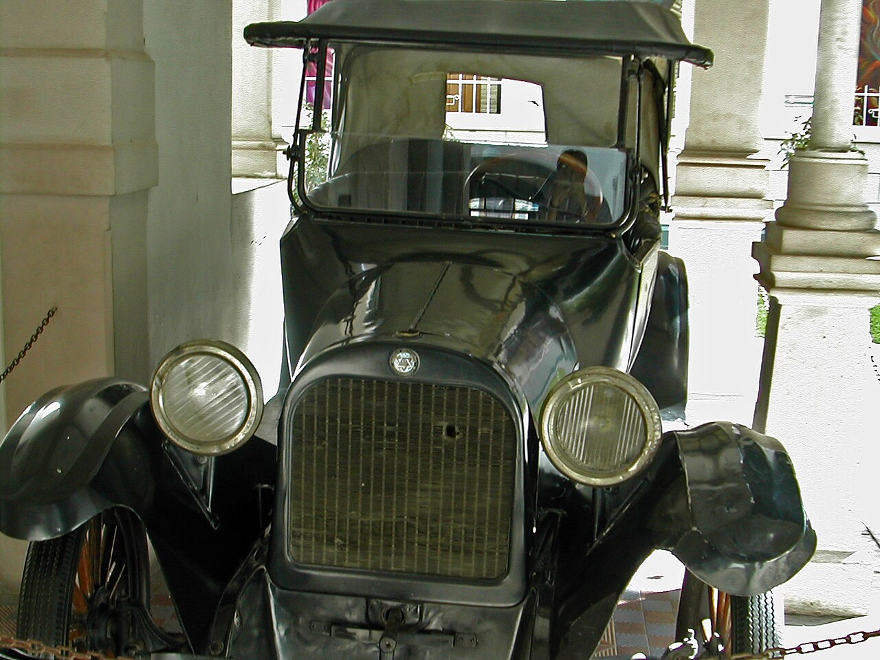
- Casa Redonda, Museum of Contemporary Art — North of the centre
Chihuahua's Casa Redonda, or Round House, was once a workshop for the national railways. Its circular brick structure now holds contemporary art, and the building is worth the visit even when the exhibition does not appeal. It makes a good outing for a cooler morning or late afternoon. - Federal Palace — Historic centre
The Federal Palace in Chihuahua now works as a modern art museum. Its other claim is historical: a former cell inside held Father Miguel Hidalgo before his execution, and visitors can see it. Pair it with the nearby Temple of San Francisco, where Hidalgo was first buried. - Quinta Gameros — Near the centre
Quinta Gameros is an Art Nouveau mansion from the days of the northern mining and cattle fortunes. Chihuahua's decorative-arts museum fills its rooms with period furniture, with the ornate interior as the main draw. Other mansions of the same wealthy families, such as Creel and Terrazas, are scattered close by. - El Palomar Park — Western side of the city
El Palomar is a large modern city park on ground that was once a rough district. Locals use it for walking, concerts and large public events, and it is a good place to watch Chihuahua at leisure on a weekend. Evenings are the pleasant time in summer.
Culture
Chihuahua sees itself as northern: ranching country, wide horizons and a practical, direct manner. Cowboy hats and boots are everyday wear for many men, and norteño and banda music turn up at celebrations, in cars and in restaurants. Conversation is friendly but unhurried, and meals, especially weekend grills, can stretch for hours.
The Catholic imprint is strong. Missionaries used the city as a staging post for the sierra, and the cathedral and Temple of San Francisco still hold regular services. Civic pride attaches just as firmly to the revolution. Pancho Villa is a local hero, the Government Palace carries murals on Hidalgo and the independence story, and historic anniversaries are marked with parades and ceremonies.
The city is also the gateway to the Rarámuri, or Tarahumara, whose communities live in the mountains to the west. They are known for long-distance running, weaving and wooden crafts, and some sell goods in the city. Treat them as neighbours with their own customs, not as a sight.
Local people appreciate a few Spanish phrases, and a greeting of buenos días to staff when entering a shop or restaurant is expected. Safety advice for northern Mexico changes, so read current official guidance before travelling and stick to well-lit central areas after dark.
In churches and when meeting Rarámuri artisans, keep your voice low, cover your shoulders, and always ask before photographing a person or a service.
What to wear
Chihuahua's traditional dress belongs to two worlds. The ranching tradition gives the norteño look: felt or straw hats, leather boots, denim and heavy belts, with embroidered or pearl-snap shirts for celebrations. In the sierra the Rarámuri have their own clothing. Women wear gathered, layered skirts and bright cotton blouses with headscarves, and men have historically worn white cotton tunics with a headband. These outfits are most visible at festivals and in markets.
In the city, people dress for the climate and for business. Offices and shops lean smart-casual, with jeans and boots common even in formal settings. Summer is light cotton and sunglasses, and winter brings jackets, scarves and sometimes gloves because nights drop towards freezing. Cowboy style is not costume here, and wearing it is normal.
A visitor should plan for large swings in temperature. Summer days are hot and dry, so pack breathable layers, a hat and sun cream. From late autumn to early spring, evenings are cold, and a warm jacket earns its place in the bag. Comfortable closed shoes suit the paved centre and the museum floors. For churches, bring a light scarf or shirt that covers the shoulders, and avoid very short shorts. Hiking boots are the better choice if the trip continues into the sierra.
What to eat
- Tacos with a salsa bar — Any busy taquería, particularly ones with a self-service salsa counter
Chihuahua's taquerías grill meat onto small tortillas and leave the finishing to the diner. A long salsa bar usually offers guacamole, pico de gallo and roasted salsas. Order a few different fillings, then compare the toppings. - Machaca con huevo — Breakfast cafés and family eateries
Machaca is dried, shredded beef, a northern ranching staple. Scrambled with eggs and often tomato, chile and onion, it arrives with flour tortillas and beans. It makes a sturdy breakfast before a day of museums or a drive. - Queso fundido — Restaurants around the historic centre
Chihuahua cheese is a mild melting cheese tied to the state. Served bubbling in a hot dish, often with chorizo or roasted peppers, it is scooped into warm flour tortillas. It works well as a shared starter. - Discada — Ranch-style grill restaurants and weekend stalls
Discada is a northern mixed grill cooked on a large concave metal disc. Beef, pork, sausage, bacon, onions and peppers are chopped together and cooked slowly, then served with tortillas and salsa. It is made for sharing and best eaten with company. - Carne asada and smoked meats — Grill rooms and smokehouse-style restaurants
Grilling is a northern habit, and carne asada is the standard order, served with beans, grilled onions and tortillas. A few smokehouses also offer slow-cooked brisket and ribs in a Texas manner, a nod to the border country to the north.
Plan it
Best time. March–April and October–November, when days are warm and dry and nights are not too cold. June is the hottest month, with daytime highs around 33 °C and occasional spells above 38 °C. January days are mild, about 18 °C, but nights fall close to 2 °C and can go below freezing during cold fronts.
How long. 2–3
Getting there. Fly to General Roberto Fierro Villalobos International Airport, then take a taxi or ride-hailing car into the city. Driving from the Ciudad Juárez–El Paso border takes about four hours on the expressway south. Within the city, taxis cover the gaps between sights.
Budget. mid
Tips
- Visit museums and the cathedral in the morning, then rest in the afternoon heat in summer
- Carry a warm layer from late autumn to early spring, because evenings turn cold quickly
- Check opening days for museums on the official site, http://www.municipiochihuahua.gob.mx, or locally before heading out
- Keep some cash for small eateries, markets and craft sellers, though many restaurants take cards
- Check current official travel advice for northern Mexico before booking, and stay on well-lit central streets at night
Etiquette
- Greet staff with buenos días or buenas tardes when entering a shop or restaurant
- Keep voices low and shoulders covered in churches, and avoid photographing worshippers
- Ask before photographing Rarámuri people or their crafts, and buy directly from the maker where you can
Nearby
Sources
- Wikidata Q61302 (CC0)
- Wikipedia: Chihuahua City (rev 1381578789) (CC BY-SA 4.0)
- Wikivoyage: Chihuahua (rev 5397577) (CC BY-SA 4.0)
- Photo: Chihuahua montage, El Sombrerero (CC BY-SA 4.0)
- Photo: Deza y Ulloa statue, Lyricmac (CC BY 3.0)
- Photo: Hidalgo mural panel, Lyricmac (CC BY-SA 2.0)
- Photo: Batalla de Sacramento, F. Bastin (Public domain)
- Photo: Government Palace mural, Lyricmac (Public domain)
- Photo: Pancho Villa's car, unknown author (CC BY-SA 2.0)
- Photo: Obelisco Batalla del Arroyo del Mortero, Levi Martinez-Reza (CC BY-SA 4.0)
- Photo: La Trinidad monument, Battroid (CC BY 3.0)


